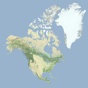
A detailed physical relief map depicting the continent of North America alongside Greenland, rendered in muted natural colors that indicate terrain and vegetation zones. The Rocky Mountains and Sierra Nevada are visible as darker green and brown ridges along the western coast, while the Great Plains appear as pale tan expanses in the interior. Greenland dominates the upper right, shown largely in white to represent its ice sheet, with the Canadian Arctic Archipelago visible to its west.
All photos
Nov 23, 2020
Nov 23, 2020
Aug 9, 2020
Aug 9, 2020

Physical Relief Map of North America and Greenland

Physical Relief Map of North America and Greenland
Physical Relief Map of North America and Greenland
Physical Relief Map of North America and Greenland